

Product Details
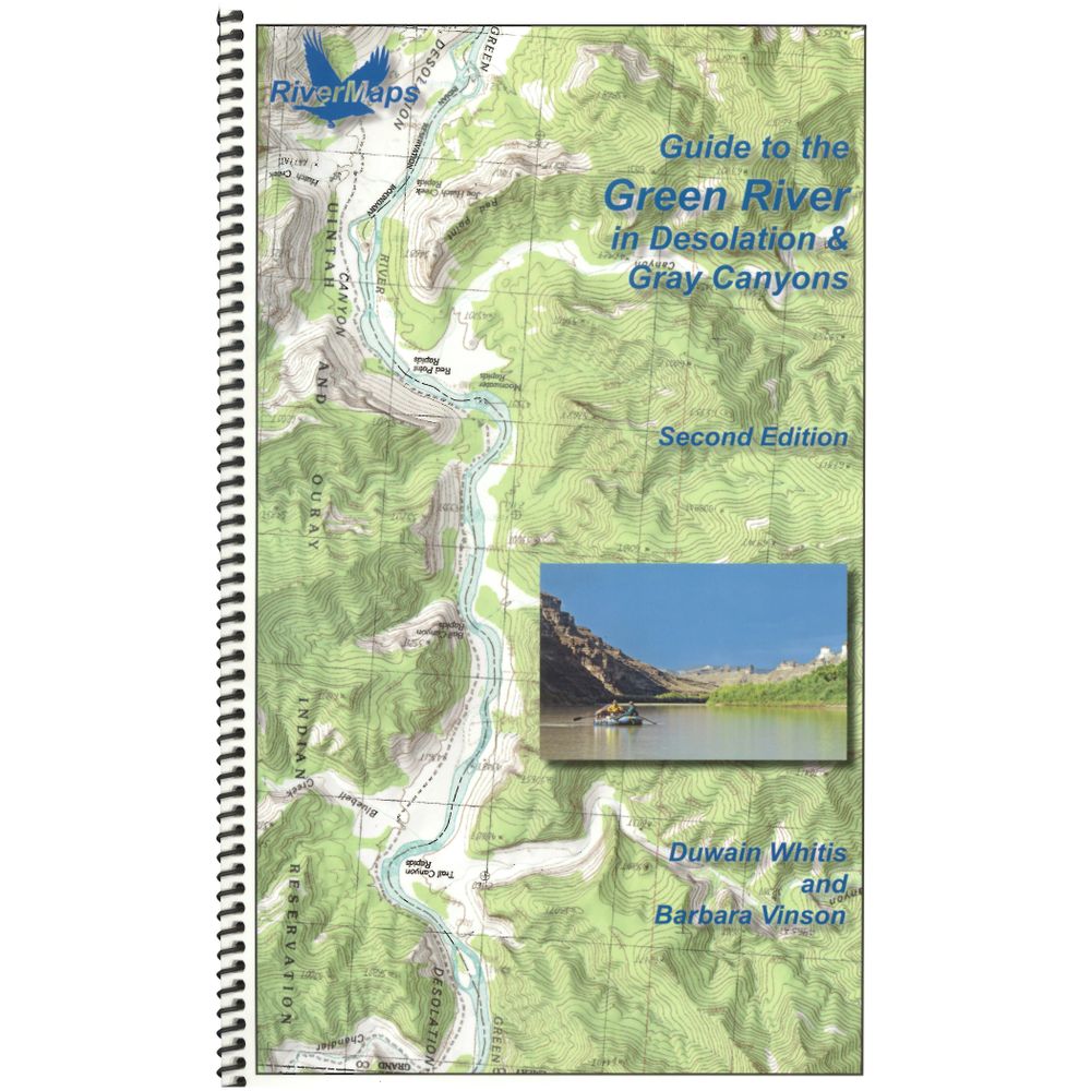
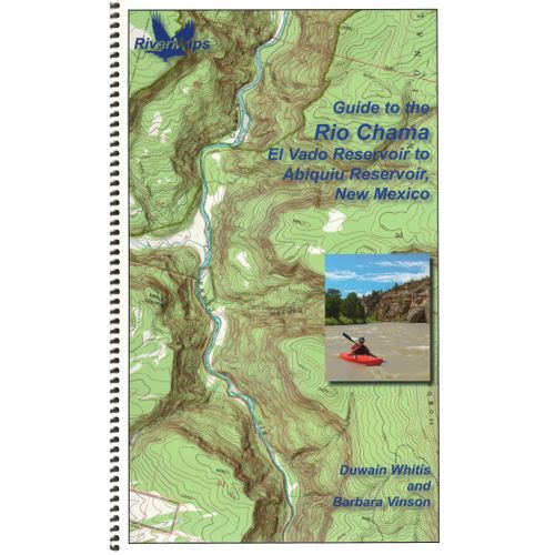
The Green River flows through Desolation and Gray Canyons in Utah and this RiverMaps™ guidebook shows you the way through all the rapids, campsites and places of interest.
Copyright: 2018, 2nd Edition
Size: 9" x 14"
Pages: 43
- RiverMaps guidebooks are made by river runners for river runners.
- The 2nd Edition extends the original 84 mile trip from the Sand Wash put-in to the Swaseys Ramp takeout to 96 miles now that Tusher Dam allows boats to pass to take out at the Green River State Park Boat Ramp.
- Spiral bound construction lets the pages lie flat and high quality waterproof, tear-resistant paper handles the splash and abuse of negotiating rivers.
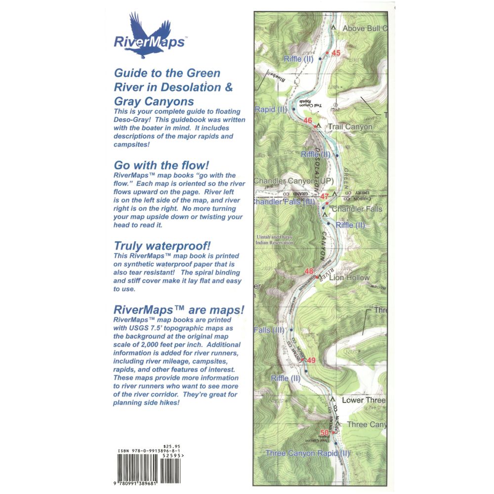
- Full-color topo maps on the right side and complete mile-by-mile text descriptions of major rapids, campsites and features of interest on the facing page.
- USGS topographic maps at the scale of 2,000 feet to the inch (1:24,000). There's no better way to keep track of where you are on the river.
- The front 13 pages offer BLM contact info and regulations, tribal contact and permit info, weather, geology, archaeology, history, ecology and resource protection wisdom.
- No matter what other resources you have, this guidebook is an essential tool for enjoying these magnificent river trips.
Copyright: 2018, 2nd Edition
Size: 9" x 14"
Pages: 43
Specs
| Subject Matter: |
|
|---|---|
| Subject Location: | Southwest |
| Author: | Duwain Whitis & Barbara Vinson |
| Copyright: | 2018, 2nd Edition |
| Size: | 9" x 14" |
| Pages: | 43 |
| Features: |
|
'%3e%3cg id='Final-Copy-2_2_' transform='translate(1275.000000, 200.000000)'%3e%3cpath class='st0' d='M7.4,12.8h6.8l3.1-11.6H7.4C4.2,1.2,1.6,3.8,1.6,7S4.2,12.8,7.4,12.8z'/%3e%3c/g%3e%3c/g%3e%3c/g%3e%3cg id='final---dec.11-2020'%3e%3cg id='_x30_208-our-toggle' transform='translate(-1275.000000, -200.000000)'%3e%3cg id='Final-Copy-2' transform='translate(1275.000000, 200.000000)'%3e%3cpath class='st1' d='M22.6,0H7.4c-3.9,0-7,3.1-7,7s3.1,7,7,7h15.2c3.9,0,7-3.1,7-7S26.4,0,22.6,0z M1.6,7c0-3.2,2.6-5.8,5.8-5.8 h9.9l-3.1,11.6H7.4C4.2,12.8,1.6,10.2,1.6,7z'/%3e%3cpath id='x' class='st2' d='M24.6,4c0.2,0.2,0.2,0.6,0,0.8l0,0L22.5,7l2.2,2.2c0.2,0.2,0.2,0.6,0,0.8c-0.2,0.2-0.6,0.2-0.8,0 l0,0l-2.2-2.2L19.5,10c-0.2,0.2-0.6,0.2-0.8,0c-0.2-0.2-0.2-0.6,0-0.8l0,0L20.8,7l-2.2-2.2c-0.2-0.2-0.2-0.6,0-0.8 c0.2-0.2,0.6-0.2,0.8,0l0,0l2.2,2.2L23.8,4C24,3.8,24.4,3.8,24.6,4z'/%3e%3cpath id='y' class='st3' d='M12.7,4.1c0.2,0.2,0.3,0.6,0.1,0.8l0,0L8.6,9.8C8.5,9.9,8.4,10,8.3,10c-0.2,0.1-0.5,0.1-0.7-0.1l0,0 L5.4,7.7c-0.2-0.2-0.2-0.6,0-0.8c0.2-0.2,0.6-0.2,0.8,0l0,0L8,8.6l3.8-4.5C12,3.9,12.4,3.9,12.7,4.1z'/%3e%3c/g%3e%3c/g%3e%3c/g%3e%3c/g%3e%3c/svg%3e) Your Privacy Choices
Your Privacy Choices NRS Gift Card: Always Fits, Always Wanted


