

Product Details
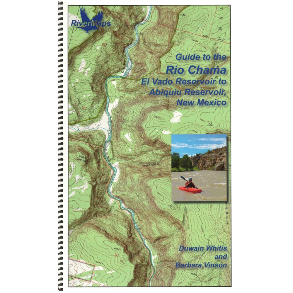
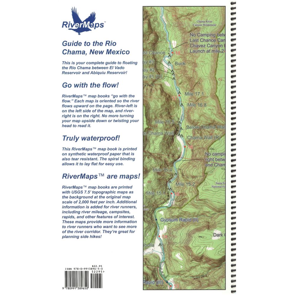
The RiverMaps™ Guide to the Rio Chama is the go-to mile-by-mile guide for planning a trip and navigating the Rio Chama, one of the major tributaries of the Rio Grande.
Copyright: 2017
Size: 9" x 14"
Pages: 23
- Flowing through scenic canyons in northwestern New Mexico, the Rio Chama is forgiving enough for the less experienced but challenging enough to keep the experienced boater's attention.
- Covers 31 miles of the Rio Chama from put-in at Cooper's El Vado Ranch to the Big Eddy takeout.
- The first 25 miles of the Rio Chama featured in this guide are designated Wild & Scenic. Permit requirements and regulations are included.
- Despite its relatively short length, The Rio Chama is one of the more hydrologically altered rivers in the western U.S., and this guide offers recommended minimum flows among other tips.
- Spiral bound format with full color topo maps on the right side and complete text descriptions on the facing page.
- Excellent mile by mile information on rapids, campgrounds, geological features, historical sites and reference points.
- The topo maps are the same scale as the original USGS maps. The contour lines and accurate shape of the river really help you keep track of where you are.
- The high-quality waterproof paper won't tear and the ink won't bleed even after going through the harshest rapids.
Copyright: 2017
Size: 9" x 14"
Pages: 23
Specs
| Weight: | 4.8 oz |
|---|---|
| Subject Matter: |
|
| Subject Location: | Southwest |
| Author: | Duwain Whitis & Barbara Vinson |
| Copyright: | 2017 |
| Size: | 9" x 14" |
| Pages: | 23 |
| Features: |
|

'%3e%3cg id='Final-Copy-2_2_' transform='translate(1275.000000, 200.000000)'%3e%3cpath class='st0' d='M7.4,12.8h6.8l3.1-11.6H7.4C4.2,1.2,1.6,3.8,1.6,7S4.2,12.8,7.4,12.8z'/%3e%3c/g%3e%3c/g%3e%3c/g%3e%3cg id='final---dec.11-2020'%3e%3cg id='_x30_208-our-toggle' transform='translate(-1275.000000, -200.000000)'%3e%3cg id='Final-Copy-2' transform='translate(1275.000000, 200.000000)'%3e%3cpath class='st1' d='M22.6,0H7.4c-3.9,0-7,3.1-7,7s3.1,7,7,7h15.2c3.9,0,7-3.1,7-7S26.4,0,22.6,0z M1.6,7c0-3.2,2.6-5.8,5.8-5.8 h9.9l-3.1,11.6H7.4C4.2,12.8,1.6,10.2,1.6,7z'/%3e%3cpath id='x' class='st2' d='M24.6,4c0.2,0.2,0.2,0.6,0,0.8l0,0L22.5,7l2.2,2.2c0.2,0.2,0.2,0.6,0,0.8c-0.2,0.2-0.6,0.2-0.8,0 l0,0l-2.2-2.2L19.5,10c-0.2,0.2-0.6,0.2-0.8,0c-0.2-0.2-0.2-0.6,0-0.8l0,0L20.8,7l-2.2-2.2c-0.2-0.2-0.2-0.6,0-0.8 c0.2-0.2,0.6-0.2,0.8,0l0,0l2.2,2.2L23.8,4C24,3.8,24.4,3.8,24.6,4z'/%3e%3cpath id='y' class='st3' d='M12.7,4.1c0.2,0.2,0.3,0.6,0.1,0.8l0,0L8.6,9.8C8.5,9.9,8.4,10,8.3,10c-0.2,0.1-0.5,0.1-0.7-0.1l0,0 L5.4,7.7c-0.2-0.2-0.2-0.6,0-0.8c0.2-0.2,0.6-0.2,0.8,0l0,0L8,8.6l3.8-4.5C12,3.9,12.4,3.9,12.7,4.1z'/%3e%3c/g%3e%3c/g%3e%3c/g%3e%3c/g%3e%3c/svg%3e) Your Privacy Choices
Your Privacy Choices NRS Gift Card: Always Fits, Always Wanted


